Category: Uncategorized

  • DHOLAVIRA SITE .ANCIENT WONDER


     DHOLAVIRA IS FAMOUS

    Dholavira location is on the Tropic of Cancer. It is one of the five largest Harappan sites and most prominent archaeological sites in India belonging to the Indus Valley Civilization. It is also considered as having been the grandest of cities of its time.


    ABOUT DHOLAVIRA

    UNESCO has included Dholavira of Kutch in the list of World Heritage Sites in 2021, giving Gujarat the opportunity to shine once again on the World Heritage Map. With the inclusion of Dholavira in the World Heritage Site, Gujarat has also got the pride of being a state with four World Heritage Sites.

    About The Location: 

    • the height of our civilization, our technological development, our social and material complexity, all signs point to progress, we often think. And yet, all is not as it seems and once in a while it occurs to us to look into the past to discover our future.
    • Dholavira is the larger of the two most remarkable excavations of the Indus Valley Civilization or Harappan culture, dating back to 4500 years ago. While the other site, Lothal, is more exhaustively educated and easier to reach, a visit to Lothal only complements, rather than replaces, a visit to Dholavira. What this site offers you, in the intense environment that comes with being surrounded by the Great Rann of Kutch, is a unique insight into the pioneering Harappan mind, with one of the world’s earliest and best planned water conservation systems and what might be the world’s first signboards, written in ancient Indus script.
    • The excavation also tells the story of the 7 stages of the civilization, from development to maturity to decay, the last of which hints at a strange piece of history, with more questions than answers. After the peak of the civilization Dholavira was temporarily abandoned, after which it seems that the settlers returned with a markedly de-urbanized culture. There are hints that they willingly chose to simplify their lives, rather than try to ride the collapse of their once glorified civilization. Here, on the ruins, you will have a chance to contemplate what progress and civilization mean and what, if anything, is truly permanent.

    Background:

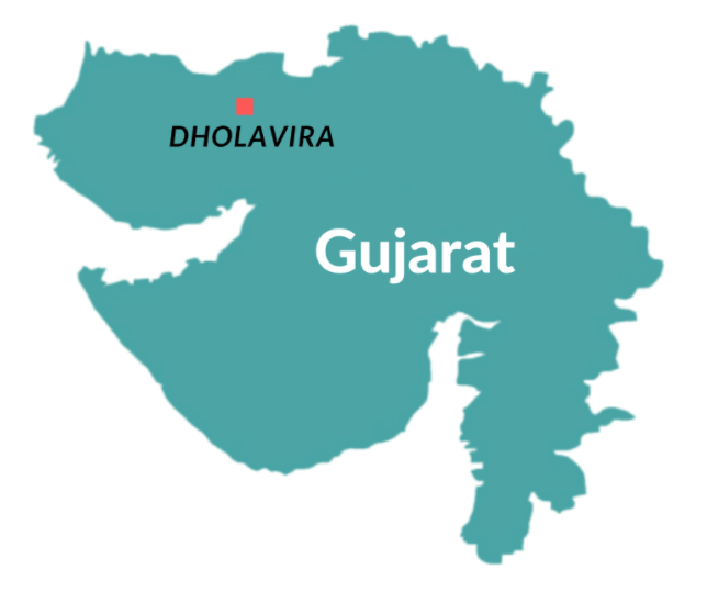
    •  Dholavira, known locally as Kotada (which means large fort), sprawls over 100 hectares of semi-arid land at the north-west corner of the island of Khadir, one of the islands in the Great Rann of Kutch that remain above the flood-plains in months when the rest of the desert is submerged by the monsoon. Dholavira has two seasonal nallahs, or streams: Mansar in the north, and Manhar in the south. The journey to Dholavira itself is beautiful, taking you through the saline desert plains of the Great Rann, where you can spot wildlife such as chinkara gazelle, nilgai (blue bull, the largest antelope in Asia), flamingos and other bird life.
    • The site was unearthed by the Archeological Survey of India (ASI) in 1967, but has been systematically excavated only since 1990. Artifacts include terracotta pottery, beads, gold and copper ornaments, seals, fish hooks, animal figurines, tools, urns, and some imported vessels that indicate trade links with lands as far away as Mesopotamia. Also found were 10 large stone inscriptions, carved in Indus Valley script, perhaps the world’s earliest signboard. These are among the most important discoveries about the Indus Valley Civilization, but remain tantalizingly undeciphered.
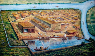
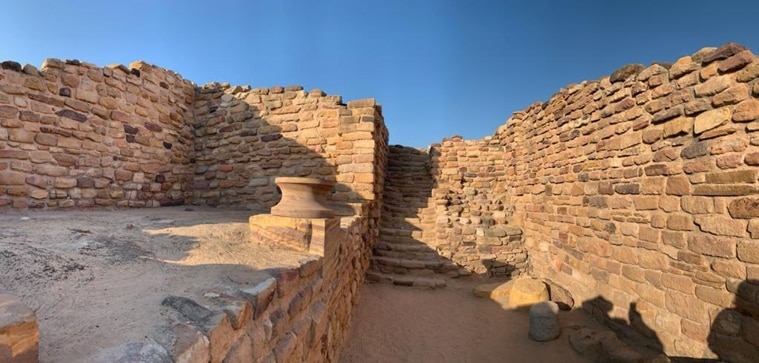
    • The remains show an imposing citadel in the center, with a middle and lower town, each fortified separately, built with pleasingly smoothed structures of sun-dried brick and stone masonry, and with remarkable town planning. Well laid out lanes lead outward systematically from the citadel, with a well-constructed underground drainage system for sanitation. There is a large stadium with a complex structure and seating arrangement.
    • Finally, Dholavira has one of the world’s earliest water conservation systems ever excavated. Satellite pictures show a reservoir underground, an expertly constructed rainwater harvesting system extending from the walls of the city, without which the settlement would not have thrived in the sparse rainfall of the desert.
    • Dholavira is one of the two largest Harappan sites in India, and 5th largest in the subcontinent. Like Lothal, it passed through all the stages of the Harappan culture from circa 2900 BC to 1500 BC, while most others saw only the early or late stages.
    • The excavation found a decline of the civilization in the 5th of 7th stages, after which were signs of a temporary desertion of the site. Settlers returned later in the late Harappan stage, with a change in their pottery, influenced by cultures found at sites in Sindh, South Rajasthan and other parts of Gujurat, but they did not bring the return of the civilization. Their houses, for example, were built in an entirely new form that was circular (bhungas), and the material signs were strikingly deurbanized and simplified. Perhaps the last stage of the powerful civilization had become aware of its future, and was preparing itself for a gradual end.
    • Dholavira, the archaeological site of a Harappan-era city, received the UNESCO world heritage site tag on Tuesday. While Dholavira became the fourth site from Gujarat and 40th from India to make the list, it is the first site of the ancient Indus Valley Civilisation (IVC) in India to get the tag

    Dholavira site

    • The IVC acropolis is located on a hillock near present-day Dholavira village in Kutch district, from which it gets its name. It was discovered in 1968 by archaeologist Jagat Pati Joshi. The site’s excavation between 1990 and 2005 under the supervision of archaeologist Ravindra Singh Bisht uncovered the ancient city, which was a commercial and manufacturing hub for about 1,500 years before its decline and eventual ruin in 1500 BC.
    • Distinct features
    • After Mohen-jo-Daro, Ganweriwala and Harappa in Pakistan and Rakhigarhi in Haryana of India, Dholavira is the fifth largest metropolis of IVC.  The site has a fortified citadel, a middle town and a lower town with walls made of sandstone or limestone instead of mud bricks in many other Harappan site
    • Archaeologist Bisht cites a cascading series of water reservoirs, outer fortification, two multi-purpose grounds — one of which was used for festivities and as a marketplace — nine gates with unique designs, and funerary architecture featuring tumulus — hemispherical structures like the Buddhist Stupas— as some of the unique features of the Dholavira site.
    • Dholavira became the fourth site from Gujarat and 40th from India to make the list. (Twitter/narendramodi)
    • He says that one finds the origin of the Buddhist Stupas in memorials in Dholavira.
    • While unlike graves at other IVC sites, no mortal remains of humans have been discovered at Dholavira. Bisht says memorials that contain no bones or ashes but offerings of precious stones, etc. add a new dimension to the personality of the Harappans.

    Rise and fall of Dholavira

    • Remains of a copper smelter indicate of Harappans, who lived in Dholavira, knew metallurgy. It is believed that traders of Dholavira used to source copper ore from present-day Rajasthan and Oman and UAE and export finished products. It was also a hub of manufacturing jewellery made of shells and semi-precious stones, like agate and used to export timber.


    • Bisht says that such beads peculiar to the Harappan workmanship have been found in the royal graves of Mesopotamia, indicating Dholavira used to trade with the Mesopotamians. Its decline also coincided with the collapse of Mesopotamia, indicating the integration of economies. Harappans, who were maritime people, lost a huge market, affecting the local mining, manufacturing, marketing and export businesses once Mesopotamia fell.
    • He further says that from 2000 BC, Dholavira entered a phase of severe aridity due to climate change and rivers like Saraswati drying up. Because of a drought-like situation, people started migrating toward the Ganges valley or towards south Gujarat and further beyond in Maharashtra.
    • In those times, Bisht says, the Great Rann of Kutch, which surrounds the Khadir island on which Dholavira is located, used to be navigable, but the sea receded gradually and the Rann became a mudflat.

    Conservation

    • Though it was excavated recently, the Dholavira site has remained free from encroachment in historical periods as well as in the modern era. Bisht says the UNESCO listing became possible because the site was found free from any kind of encroachment, a rarity in India.
    • In its release, UNESCO termed Dholavira as one of the most remarkable and well-preserved urban settlements in South Asia dating from the 3rd to mid-2nd millennium BCE (Before Common Era). Since the excavation at the site, the ASI has developed a museum here. Dholavira, a village with a population of around 2,000, is the nearest human settlement at present. Near the ancient city is a fossil park where wood fossils are preserved.

    Recently, UNESCO has announced the Harappan city of Dholavira in Gujarat as India’s 40th world heritage site. It is the first site of Indus Valley Civilisation (IVC) in India to be included on the coveted list.
    With this successful nomination, India now enters the Super-40 club for World Heritage Site inscriptions.
    Apart from India, Italy, Spain, Germany, China and France have 40 or more World Heritage sites.
    India has 40 world heritage sites overall, which includes 32 cultural, 7 natural and one mixed property. Ramappa Temple (Telangana) was India’s 39th World Heritage Site.
    Key Points
    About Dholavira:
    • It is one of the most remarkable and well-preserved urban settlements in South Asia.
    • It was discovered in 1968 by archaeologist Jagat Pati Joshi.
    • After Mohen-jo-Daro, Ganweriwala and Harappa in Pakistan and Rakhigarhi in Haryana of India, Dholavira is the fifth largest metropolis of Indus Valley Civilization (IVC).
    • IVC flourished around 2,500 BC, in the western part of South Asia, what today is Pakistan and Western India. It was basically an urban civilization and the people lived in well-planned and well-built towns, which were also the centers for trade.
    • The site contains ruins of an ancient IVC/Harappan city. It comprises two parts: a walled city and a cemetery to the west of the city.
    • The walled city consists of a fortified Castle with attached fortified Bailey and Ceremonial Ground, and a fortified MiddleTown and a Lower Town.
    • A series of reservoirs are found to the east and south of the Citadel.
    Location:
    The ancient city of Dholavira is an archaeological site at Kachchh District, in the state of Gujarat, which dates from the 3rd to mid-2nd millennium BCE.
    Dholavira’s location is on the Tropic of Cancer.
    • It is located on Khadir bet island in the Kachchh Desert Wildlife Sanctuary in the Great Rann of Kachchh.
    • Unlike other Harappan antecedent towns normally located near to rivers and perennial sources of water, the location of Dholavira in the island of Khadir bet.
    • This was strategic to harness different mineral and raw material sources (copper, shell, agate-carnelian, steatite, lead, banded limestone, among others).
    • It also facilitated internal as well as external trade to the Magan (modern Oman peninsula) and Mesopotamian regions.
    Archeological Findings:
    • Artifacts that were found here include terracotta pottery, beads, gold and copper ornaments, seals, fish hooks, animal figurines, tools, urns, and some imported vessels.
    • Remains of a copper smelter indicate Harappans, who lived in Dholavira, knew metallurgy.
    • It is believed that traders of Dholavira used to source copper ore from present-day Rajasthan and Oman and UAE and exported finished products.
    • It was also a hub of manufacturing jewellery made of shells and semi-precious stones, like agate and used to export timber.
    • 10 large stone inscriptions, carved in Indus Valley script, perhaps the world’s earliest sign board.
    • Near the ancient city is a fossil park where wood fossils are preserved.
    • Unlike graves at other IVC sites, no mortal remains of humans have been discovered at Dholavira.
    Distinct Features of the Dholavira Site:
    • Cascading series of water reservoirs.
    • Outer fortification.
    • Two multi-purpose grounds, one of which was used for festivities and other as a marketplace.
    • Nine gates with unique designs.
    • Funerary architecture featuring tumulus — hemispherical structures like the Buddhist Stupas.
    • Multi-layered defensive mechanisms, extensive use of stone in construction and special burial structures.
    Decline of Dholavira:
    • Its decline also coincided with the collapse of Mesopotamia, indicating the integration of economies.
    • Harappans, who were maritime people, lost a huge market, affecting the local mining, manufacturing, marketing and export businesses once Mesopotamia fell.
    • Dholavira entered a phase of severe aridity due to climate change and rivers like Saraswati drying up.
    • Due to a drought-like situation, people started migrating toward the Ganges valley or towards south Gujarat and further beyond in Maharashtra.
    • Further, the Great Rann of Kutch, which surrounds the Khadir island on which Dholavira is located, used to be navigable, but the sea receded gradually and the Rann became a mudflat.

    Other Harappan sites in Gujarat
    • Before Dholavira was excavated, Lothal, in Saragwala village on the bank of Sabarmati in Dholka taluka of Ahmedabad district, was the most prominent site of IVC in Gujarat.
    • It was excavated between 1955 and 1960 and was discovered to be an important port city of the ancient civilisation, with structures made of mud bricks. From a graveyard in Lothal, 21 human skeletons were found. Foundries for making copperware were also discovered. Ornaments made of semi-precious stones, gold etc. were also found from the site.
    • Besides Lothal, Rangpur on the bank of Bhadar river in Surendranagar district was the first Harappan site in the state to be excavated. Rojdi in Rajkot district, Prabhas near Veraval in Gir Somnath district, Lakhabaval in Jamnagar, and Deshalpar in Bhuj taluka of Kutch are among other Harappan sites in the state.
    • Lothal: Before Dholavira was excavated, Lothal, in Saragwala village on the bank of Sabarmati in Dholka taluka of Ahmedabad district, was the most prominent site of IVC in Gujarat.
    • It was excavated between 1955 and 1960 and was discovered to be an important port city of the ancient civilisation, with structures made of mud bricks.
    • From a graveyard in Lothal, 21 human skeletons were found.
    • Foundries for making copperware were also discovered.
    • Ornaments made of semi-precious stones, gold etc. were also found from the site.
    • Rangpur on the bank of Bhadar river in Surendranagar district was the first Harappan site in the state to be excavated.
    • Rojdi in Rajkot district, Prabhas near Veraval in Gir Somnath district.
    • Lakhabaval in Jamnagar, and Deshalpar in Bhuj taluka of Kutch are among other Harappan sites in the state.
    Other World Sites in Gujarat
    • Other than Dholavira, there are 3 UNESCO World Heritage Sites in Gujarat.
    • Historic city of Ahmedabad
    • Rani ki Vav, Patan
    • Champaner & Pavagadh
    UNESCO world heritage list sites in India


    Cultural (31)

    1. Agra Fort (1983)
    2. Ajanta Caves (1983)
    3. Archaeological Site of Nalanda Mahavira at Nalanda, Bihar (2016)
    4. Buddhist Monuments at Sanchi (1989)
    5. Champaner-Pavagadh Archaeological Park (2004)
    6. Chhatrapati Shivaji Terminus (formerly Victoria Terminus) (2004)
    7. Churches and Convents of Goa (1986)
    8. Elephanta Caves (1987)
    9. Ellora Caves (1983)
    10. Fatehpur Sikri (1986)
    11. Great Living Chola Temples (1987,2004)
    12. Group of Monuments at Hampi (1986)
    13. Group of Monuments at Mahabalipuram (1984)
    14. Group of Monuments at Pattadakal (1987)
    15. Hill Forts of Rajasthan (2013)
    16. Historic City of Ahmadabad (2017)
    17. Humayun’s Tomb, Delhi (1993)
    18. Jaipur City, Rajasthan (2019)
    19. Khajuraho Group of Monuments (1986)
    20. Mahabodhi Temple Complex at Bodh Gaya (2002)
    21. Mountain Railways of India (1999,2005,2008)
    22. Qutub Minar and its Monuments, Delhi (1993)
    23. Rani-ki-Vav (the Queen’s Stepwell) at Patan, Gujarat (2014)
    24. Red Fort Complex (2007)
    25. Rock Shelters of Bhimbetka (2003)
    26. Sun Temple, Konârak (1984)
    27. Taj Mahal (1983)
    28. The Architectural Work of Le Corbusier, an Outstanding Contribution to the Modern Movement (2016)
    29. The Jantar Mantar, Jaipur (2010)
    30. Victorian Gothic and Art Deco Ensembles of Mumbai (2018)
    31. Ramappa temple Telangana 2021
    Natural (7)
    1. Great Himalayan National Park Conservation Area (2014)
    2. Kaziranga National Park (1985)
    3. Keoladeo National Park (1985)
    4. Manas Wildlife Sanctuary (1985)
    5. Nanda Devi and Valley of Flowers National Parks (1988,2005)
    6. Sundarbans National Park (1987)
    7. Western Ghats (2012)
    Mixed (1)
    1. Khangchendzonga National Park (2016)

    How to get there

    By Road


    Ahmedabad is 335 ilometers from bhuj approx. driving time is 7 hours . Dholavira is 250 km from Bhuj and is reached via Bhachau and Rapar. A bus leaves from Bhuj at 14:00 and arrives at Dholavira at 20:30. It leaves at 05:00 the next morning and returns to Bhuj by 11:30. It is also possible to rent a vehicle.

    By Train

    The closest railway station to Dholavira is Samakhiali, just 137 kms away. Major railway stations nearby are Bhachau, Gandhidham and Anjar, which are 152, 187 and 191 Kms away respectively.

    By Air

    Major airports nearby are Kandla and Bhuj. Kandla airport stands at a distance of 191Kms, whereas Bhuj is around 215 kms away.

    NEED ANY INFORMATION CONTACT ADM WONDERSINDIA@GMAIL.COM

    UP DATES

  • KANCHENDZONGA NATIONAL PARK

    Located at the guts of the mountain range zero in northern Republic of India (State of Sikkim), the Khangchendzonga parkland includes a singular diversity of plains, valleys, lakes, glaciers and spectacular, covering mountains lined with ancient forests, together with the world’s third highest peak, Mount Khangchendzonga. Mythological stories square measure related to this mountain and with an excellent range of natural parts (caves, rivers, lakes, etc.) that square measure the thing of worship by the autochthonous folks of geographical region. The sacred meanings of those stories and practices are integrated with Buddhist beliefs and represent the idea for Sikkimese identity.

    • Khangchendzonga park conjointly Kanchenjunga region Reserve could be a park and a region reserve situated in geographical region, India. it absolutely was inscribed to the UN agency World Heritage Sites list in July 2016, changing into the primary “Mixed Heritage” web site of Asian nation. it absolutely was enclosed within the UN agency Man and also the region Programme. The park is called once the mountain Kangchenjunga (alternative writing system Khangchendzonga), that is that the third-highest peak within the world at eight,586 metres (28,169 ft) tall. the overall space of the park is 849.5 km2 (328.0 sq mi).
    • A 2014 study discovered, that the Cuon alpinus has become terribly rare within the space. The wild dogs within the Khangchendzonga region Reserve ar thought to belong to the rare and genetically distinct taxon C. a. primaevus.
    • Avifauna
    • About 550 species of birds ar found within the park as well as blood pheasant, satyr pheasant, osprey, range of mountains griffon, Old World vulture, Western pheasant, inexperienced columbiform bird, Tibetan snowcock, snow columbiform bird, impeyan pheasant, Asian emerald cuckoo, sunbird and eagle. a replacement species of bird named range of mountains Forest Thrush has been found in 2016. Its scientific name is Zoothera salimalii.

      Park specific activities

      • Trekking
      • Most of the trekking routes begin from Yuksom (145 kilometer (90 mi) from Gangtok) in West geographical region. Necessary allow will be obtained from the life Education and Interpretation center at Yuksom or from the check post. State touristry Department at the side of alternative travel agents organize treks to Dzongri (4,050 metres (13,290 ft)) and alternative places. the favored trek routes are:

      • Yuksom – Tshoka – Dzongri
      • Bakim – Dzongri – Thangshing – Samuteng – Goechala
      • Dzongri Base Camp – Rathong – Khangerteng
      • Thangshing – Lam Pokhari – Kasturi Orar – Labdang – Tashiding
      • Another widespread trekking purpose includes a path to the inexperienced Lake with Lachen, a village in North geographical region because the start line. Foreign nationals need a restricted space allow from the Ministry of Home Affairs, Government of Asian nation, urban center to go to the park and also the associated region. Indian nationals ar needed to get associate degree Inner Line allow from the State Home Department. Permission of the State Chief life lawman is additionally necessary for everyone visiting the park. The vital and widespread routes are:
      • Lucanes Jakchen-Yabuk-Rest Camp (Marco Polo Camp) – inexperienced Lake
      • Lachen-Thasngu (13,695 feet (4,174 m)) – Muguthang (16,000 feet (4,900 m)) – Thay La (17,000 feet (5,200 m)) – Khyoksa La (18,000 feet (5,500 m)) – Rest Camp – inexperienced Lake.
      • Most of those trekking routes withstand the Kanchenjunga park and is shown within the film Singalila within the Himalaya

      Transport

      • Nearest airport:
      • Pakyong field, a Greenfield project close to Gangtok
      • Bagdogra field, Darjeeling district, state (222 kilometer (138 mi))
      • Gangtok Helipad, East geographical region district, Sikkim
      • Nearest railhead: New Jalpaiguri, Siliguri Junction (221 kilometer (137 mi))
      • Nearest highway: American state 31A (Sevok – Gangtok)
      • Nearest town: Yuksom in West and Chungthan in North (20 kilometer (12 mi))
      • Nearest city: Gangtok
    • GWALIOR FORT,AWONDER FORT


      An fine arts marvel of the eighth century, the Gwalior Fort is alert on a peak. The structure of the fort contains 2 main palaces, temples and water tanks. Amongst it, the foremost acknowledged is that the Teli-Ka-Mandir and Man Singh Palace. the previouswas inbuilt the Dravidian vogue shrine and its liberally carven exteriors area unit extremely appreciated. Then there’s the person Singh Palace, designed by king Man Singh within the fifteenth century. The purported Palace has a tremendous style. With blue ceramic tiles at the front façade and a powerful structure the person Singh Palace reflects actuality colors of the Tomar folk. to enhance the person Singh Palace, the Gwalior Fort advanced conjointly homes the Gujari Mahal. This was designed by Raja Man Singh for his beloved queen Mrignayani. alternative notable structures within the majestic Gwalior defence area unit the Karan Palace, the Jahangir Mahal and Shahjahan Mahal.

      Gwalior Fort, situated on top of a hill, finds its place among the best fortress in india It is also considered to be one of the most impenetrable forts in the country. Known for its great architecture and rich past, Gwalior Fort is a must-visit attraction when visiting central india Read about the history of the fort here, and find out what makes it such a wonder.

      LOCATION


      • The Gwalior Fort is a hill fort near Gwalior, Madhya Pradesh state, in India
      • Geographically located north west india
      • Near by thar desert

       LATITUDE AND LONGITUDE

      • 26.2303 North latitude
      • 78.1689 East longitude

       MSL ( MEAN SEA LEVEL)

      The elevation or mean sea level of gwaliour197 meters (or)  646 ft above sea level

       CLIMATE

      • Climate of Gwalior lives on extremes in each summer and winter. Summer typically gets extremely popular and in Gwalior the winter is extremely cold. typically rain in Gwalior is merely within the months of monsoon. primarily the north-western winds move, the speed of air within the town of Gwalior is sometimes eight kilometer per hour in summer, two kilometer per hour in winter time. Oct to March is that the best month for arrival in Gwalior town.
      • During the summer months, the climate of Gwalior is dominated by the warmth conjointly the} level of humidness also will increase. From Gregorian calendar month to Gregorian calendar month of the month of Gregorian calendar month, Gwalior gets forty five to forty seven C temperature. The climate of Gwalior is especially wet within the year. Gwalior has three hundred average temperatures in summer.
      • In the winter season, the temperature of Gwalior goes upto two degrees astronomer. within the winter months, the common minimum temperature is eighteen.500 centigrade in Gwalior.
      • Due to the geographics of Bharat, Gwalior town falls within the shadow of rain. Consequently, there’s solely 700 millimetre average rain annually, that is sort of [*fr1] the common of alternative cities within the state. Here the monsoon starts from period of time and typically continues until period of time

       LOCAL LANGUAGE

      • Hindi
      • Marwari

      Best time to visit

      The best time to go to the Gwalior Fort is throughout the time of year and spring season, that’s between October and March. One can even get pleasure from the visit throughout the time of monsoon once the encircling is abundant inexperienced, and therefore the air is recent and crisp.

      Mobile Network availability in 
      Gwalior 


      • Bsnl
      • Airtel
      • Jio
      • Idea
      • Vodafone

      Gwalior FORT is famous for (more…)